
LiDAR
Architecture & Engineering
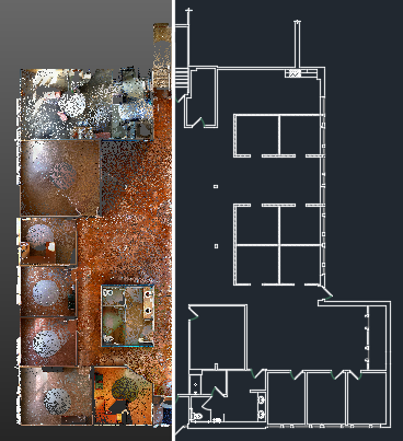
LiDAR for Architecture & Engineering
LiDAR can be used to create existing condition drawings which provides the ability to prepare everything from 2D CAD plans to a 3D SketchUp Model. It can also be used to document the entire construction process; Capturing mechanical, electrical, and plumbing at a high level of detail before the walls are closed up.
Provides the ability to capture more information quickly that is more accurate than measuring by hand
Saves previous information if ever needed in the future
Allows for the creation of existing 2D CAD drawings more efficiently and precisely
Minimizes human error for hand measuring
Creates data set that is shareable to architects and engineers

Benefits of LiDAR for Architects & Engineers
LiDAR makes field measuring easier, providing more data at a faster rate and completely eliminating the process of measuring by hand. For example, it can be used to document damage for an insurance claim, preserve historic architecture when no documents exist, or measure pipe diameter and slope in wastewater treatment plants.
Capture Accurate Data
Provides precise data with an accuracy of 2mm or 1/16 inch with a range up to 80 meters or 262 feet
Dimensionally accurate with measurable and shareable data set from Trimble Scan Explorer
Optimize Efficiency
Eliminate on site disruption and revisits
Scanning duration as fast as 1 min 34 sec at speeds of up to 500kHz, the equivalent of 500,000 data points per second
Captures more information than traditional means
Benefit from Reduced Costs
Produce accurate design plans from the start
Reduce change orders, delays, and associated costs
Measurement gathering and photo acquisition done by machine which saves in-field labor costs


